


Countries
Cities
Europe
Africa
Asia
North America
South America
Australia_Oceania
Calendar
Date
Moon
Int.Country Code +254 ccTLD .ke Car: EAK

 999
999  999
999  999
999
Current Time / Date in Nairobi
| City/Community: | Nairobi |
| Country/Region: | Kenya |
| Local Time: | 23:48 or 11:48 pm |
| Local Date: | Wednesday, 7.March 2018 |
| Current difference from CET: | +2 hours |
Current Weather in Nairobi Dagoretti
in 5899 ft / 1798 m Altitude
Last Updated on March 7, 11:00 PM EAT

Temperature: 66 ┬░F (19 ┬░C) / Windchill: 25.1 ┬░C
Wind speed: mph / 0.00 km/h
Rel.Humidity: 78 %
Pressure: 1022 mbar = hPa
© Weather Underground NOAA Weather Station
Distances
| Frankfurt, D | 6.265 km |
| Moscow, RUS | 6.227 km |
| Mumbai, IND | 5.431 km |
| Singapore | 7.452 km |
| Hong Kong, HK | 8.813 km |
| Shanghai, CN | 9.587 km |
| Beijing, CN | 9.214 km |
| Seoul, Korea | 10.073 km |
| Rio, Brazil | 8.831 km |
| Cape Town, ZA | 4.024 km |
| Sydney, AUS | 12.249 km |
| Auckland, NZ | 14.033 km |
| Honolulu, HI | 17.379 km |
| Los Angeles | 15.454 km |
| New York City | 11.769 km |
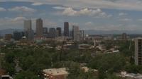
Information of Nairobi
Nairobi (; locally [na╔¬╦łro╦Ébi]) is the capital and largest city of Kenya. The name comes from the Maasai phrase Enkare Nyrobi, which translates to "cool water", a reference to the Nairobi River which flows through the city. more...
More Cities
Gilgil, Kandara, Kangema, Karatina, Karuri, Kerugoya, Kiambu, Kijabe, Kikuyu, Limuru, Makuyu, Maragua, Murang'a, Nyeri, Ol Kalou, Othaya, Ruiru, Sagana, Thika, Gazi, ...more

Airports close-by
Eldoret Intl EDL Altitude: 6941 miles
Nairobi Wilson WIL Altitude: 5546 miles
Jomo Kenyatta International/ Nairobi NBO Altitude: 5327 miles
Mara Serena Airport/ Masai Mara MRE Altitude: 500 miles
Kericho KEY Altitude: 6453 miles
Kerio Valley/ Kimwarer KRV Altitude: 7095 miles
...more
Differences to World Time (UTC)
Current World Time(UTC): 20:48 or 8:48 pm
Current Date(UTC): Wed Mar 7, 2018
Wednesday, 7.3.2018
Coordinates: 1┬░ 0' S, 36┬░ 0' O
Local Time Zone: East Africa Time (EAT)
Normal Difference from UTC: +3
Current Difference from UTC: +3
No Daylight Saving adjustments known.
Pictures from Kenya
Astronomical Data
Signs of the Zodiac: PISCES (20.2.2018 - 20.3.2018)
Longitude: -1,0000┬░
Lattitude: 36,0000┬░
Coordinates: 1┬░ 0' S, 36┬░ 0' O
 | day before yesterday | yesterday | today | tomorrow | day after tomorrow |
| Sunrise | 06:42 | 06:42 | 06:42 | 06:41 | 06:41 |
| Sunset | 18:52 | 18:51 | 18:51 | 18:51 | 18:51 |
| Sun hours [hh:mm] | 12:10 | 12:09 | 12:09 | 12:10 | 12:10 |
| Twilights: | yesterday | today | tomorrow | ||
| Civilian Twilight | Begin | 06:21 | 06:21 | 06:21 | |
| Civilian Twilight | End | 19:12 | 19:12 | 19:12 | |
| Nautical Twilight | Begin | 05:57 | 05:57 | 05:57 | |
| Nautical Twilight | End | 19:36 | 19:36 | 19:36 | |
| Astronomical Twilight | Begin | 05:33 | 05:33 | 05:33 | |
| Astronomical Twilight | End | 20:01 | 20:00 | 20:00 |
Larger map
| March 2018 | ||||||
|---|---|---|---|---|---|---|
| Su | Mo | Tu | We | Th | Fr | Sa |
| 1 | 2 | 3 | 4 | |||
| 5 | 6 | 7 | 8 | 9 | 10 | 11 |
| 12 | 13 | 14 | 15 | 16 | 17 | 18 |
| 19 | 20 | 21 | 22 | 23 | 24 | 25 |
| 26 | 27 | 28 |
Add this page to your Faves/Bookmarks E-Mail
All Rights reserved. © P.Wienzek 2008 - MMIX MMX MMXI MMXII MMXIII MMXIV MMXV MMXVI MMXVII MMXVIII V1.098a Generating this page took 1.9262 Seconds.
| These pages can be best viewed with Firefox. | 
|
